| Wednesday | Wednesday Night | Thursday | |
|---|---|---|---|
| Cloud Cover: | Light showers lingering with Overcast skies and warming temperatures. | Showers tapering and a little cooler. | Partly cloudy. |
| Temperatures: | 34-49 deg. F. | 19-29 deg. F. | 30-46 deg. F. |
| Wind Direction: | Southwest | West to Southwest | West to Southwest |
| Wind Speed: | 9-10 mph with gusts to 21 mph | 8-9 mph with gusts to 21 mph | 8-11 mph with gusts up to 24 mph |
| Snowfall: | 0 in. | 0-1 in. | 0 in. |
| Snow Line: |
Whitefish Range
Swan Range
Flathead Range and Glacier National Park
How to read the forecast
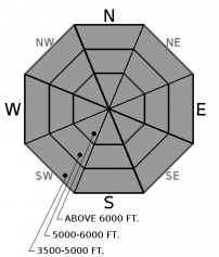
The avalanche danger is Moderate at all elevations today. Rainfall and the lack of a strong refreeze last night lead to weakening surface snow and create the potential for triggering a loose, wet avalanche. Be aware of surface snow strength continuing to deteriorate as temperatures warm.

2. Moderate
?
Above 6500 ft.
2. Moderate
?
5000-6500 ft.
2. Moderate
?
3500-5000 ft.
- 1. Low
- 2. Moderate
- 3. Considerable
- 4. High
- 5. Extreme
-
Type ?
-
Aspect/Elevation ?

-
Likelihood ?CertainVery LikelyLikelyPossible
 Unlikely
 -
Size ?HistoricVery LargeLargeSmall

Rain and warm temperatures yesterday through last night have softened the snow surface in areas. The strong supportable crust may be breaking down in places, removing its stabilizing impact. Last night, most locations did not experience a refreeze, and those that did at higher elevations did not get a strong one. As the day progresses, warming and possible additional rain will increase the loose, wet danger. Cloud cover should help limit this wet, loose avalanche activity in size and distribution. Be aware of deteriorating surface snow conditions, and avoid slopes as they soften and can't support the weight of a skier or machine. Be aware there is the possibility a loose wet avalanche could trigger a wet slab avalanche in places.
Glide cracks have been reported across the area. There is a large amount of uncertainty associated with glide cracks, so the best way to manage them is to avoid slopes where they are present. Over the past week, we've seen the variability of spring weather in the mountains. We observed large natural avalanches last Tueday-Wednesday (3/14-3/15) and Saturday (3/18) sliding on the Feb. 10 crust associated with rain storms. The Feb. 10 crust has weak sugary snow (facets) sitting on top of it in many locations and, although buried up to 4 feet deep, may continue to pose future issues. Use snowpits to continue to assess the recent, substantial load sitting atop the Feb. 10 crust. When we dig into our current snowpack, it tells a story of past powder days, a bit of wind, a whole lot of rain, and some clear temperature shifts. Each of these events that slowly shaped our snowpack throughout the season can come into play within one single day during the spring. Awareness of rapidly changing conditions is vital while enjoying the longer spring days in the mountains.
Tuesday: BNSF Avalanche Safety reported warm temperatures and mostly clear skies in the John F. Stevens Canyon. They found a mostly isothermal snowpack in a pit at 6350 feet on a south aspect but were able to get an ECT to propagate with moderate force about 40 cm from the surface.
Monday: FAC staff traveled to the Red Meadow area in the northern Whitefish Range. The surface snow moistened throughout the day, but no wet snow instability was observed. They also noted glide crack formation on some slopes. We also received an observation from the Southern Whitefish Range on Skookaleel Ridge that noted the snow surface was still solid at 12:00 and glide crack formation along the ridge near the cornices.
Sunday: FAC staff traveled to Cascadilla Creek in the Flathead Range where they noted numerous large avalanches that occurred during the March 15 warm rain event. In the morning the snow surface was unsupportable at low elevations and by early afternoon the sun had broken down the thin surface crust on sunny aspects at mid elevations making the surface unsupportable. FAC Staff also toured to Skook Ridge in the southern Whitefish Range where they found a strong supportable surface crust on all aspects. This crust was noticeably thicker on sunny aspects and the light winds kept the surface firm through most of the day. Skiers on Elk Mountain, in southern Glacier Park, found a frozen snow surface above 5600' due to strong west winds and cool temperatures.
See below for all observations this season.
Cloud cover yesterday turned to rain in the evening with variable coverage across the area. Overnight, only the weather stations above 6500 feet reached the freezing mark, with all other stations remaining above freezing. Weather stations reported variable amounts of precipitation overnight ranging from none to .5 inches. Temperatures are starting out today much warmer than yesterday. Today, expect mild temperatures reaching into the 40s F, light winds from the southwest, and only a small amount of precipitation.
| 0600 temperature: | 29-34 deg. F. |
| Max. temperature in the last 24 hours: | 38-47 deg. F. |
| Average wind direction during the last 24 hours: | Southwest to West |
| Average wind speed during the last 24 hours: | 0-12 mph |
| Maximum wind gust in the last 24 hours: | 16-22 mph |
| New snowfall in the last 24 hours: | 0-2 inches |
| Total snow depth: | 94-116 inches |
This advisory applies only to backcountry areas outside established ski area boundaries. This advisory describes general avalanche conditions and local variations always occur. This advisory expires at midnight on the posted day unless otherwise noted. The information in this advisory is provided by the USDA Forest Service who is solely responsible for its content.


