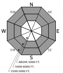
Saturday | Saturday Night | Sunday | |
---|---|---|---|
Cloud Cover: | Light precipitation tapering throughout the day with breezy conditions. | Clearing with cool temperatures. | Mostly clear with seasonal temperatures. |
Temperatures: | 29-46 deg. F. | 16-26 deg. F. | 31-47 deg. F. |
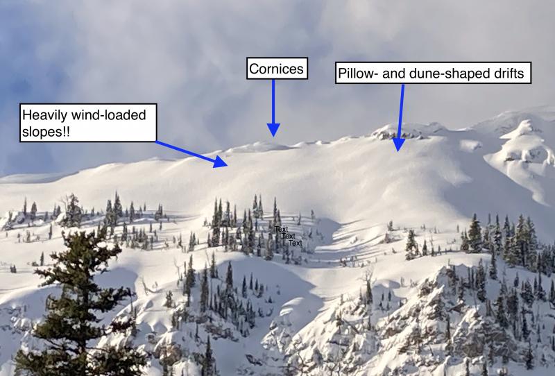
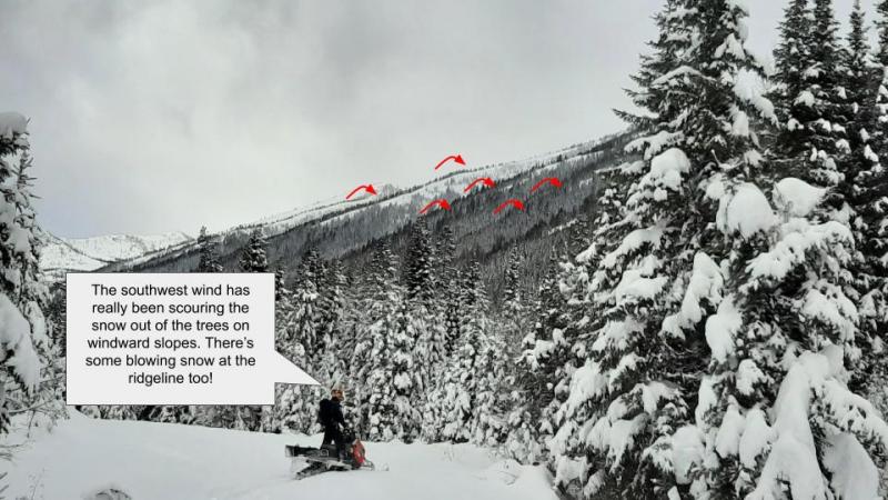
Wind Direction: | Southwest | Southwest | South-Southwest |
Wind Speed: | 12-15 mph with gusts to 28 | 14-16 with gusts to 28 | 7-10 mph with gusts to 17 |
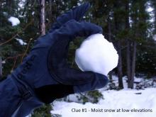
Snowfall: | 0-1 in. | 0 in. | 0 in. |
Snow Line: |
Whitefish Range
Swan Range
Flathead Range and Glacier National Park
How to read the forecast
Light snow, accompanied by wind, has created thin wind slabs in exposed upper elevation locations. These slabs were potentially deposited onto a crust and all wind loaded terrain should be evaluated before committing to a slope. At mid and low elevations light rain and above freezing temperatures have kept the surface snow moist and therefore a loose wet avalanche problem remains. The avalanche danger is LOW and safe travel techniques should be practiced.

1. Low
?
Above 6500 ft.
1. Low
?
5000-6500 ft.
1. Low
?
3500-5000 ft.
- 1. Low
- 2. Moderate
- 3. Considerable
- 4. High
- 5. Extreme
-
Type ?
-
Aspect/Elevation ?
-
Likelihood ?CertainVery LikelyLikelyPossibleUnlikely
-
Size ?HistoricVery LargeLargeSmall
Light snow returned to upper elevation locations yesterday afternoon and overnight with weather stations reporting up to 5" in John F. Stevens Canyon and interior Glacier Park. Wind speeds increased overnight with moderate to strong sustained winds with occasional extreme (>38 mph) gusts. Therefore we should expect to find thin wind slabs at upper elevations in exposed leeward locations today. In places these slabs will have been deposited onto a melt freeze crust which will make for a slippery bed surface. It seems as though it has been weeks since we last dealt with wind slabs so remember to evaluate all wind loaded terrain before committing to a slope today. These slabs are fresh and should be easy to identify by cracking in the snow beneath your skis or machine.
In areas not affected by the wind, light snow overnight may have been deposited onto a melt freeze crust in select locations. This snow may not adhere to this crust and there is a chance for triggering a loose dry avalanche. These slides will be small but they could knock you off your feet or machine and push you into a tree, over a rock outcropping or into a gulley.
-
Type ?
-
Aspect/Elevation ?
-
Likelihood ?CertainVery LikelyLikelyPossibleUnlikely
-
Size ?HistoricVery LargeLargeSmall
Above freezing temperatures overnight, coupled with light rain, has kept the surface snowpack moist at low and mid elevations and a loose wet avalanche problem remains at these elevation bands for today. This surface has been extensively "worked over" by rain and warm temperatures over the past 2 weeks but you may still be able to trigger a wet loose avalanche today. If you find your skis or machine sinking through the surface into the unconsolidated snow beneath it is best to avoid steep slopes, especially those above terrain trap features.
Giant cornices exist along most ridgelines across the advisory area. It's important to pay attention to what is looming above you given the unusual size and how overhung many of these cornices are. Keep a good distance from these while traveling along ridge lines as they can pull out further back than expected, even behind the solid ground. When a large cornice falls it has the potential to trigger deep instabilities that would otherwise remain dormant resulting in a large avalanche.
Glide cracks have also been observed opening up in many locations. There is a large amount of uncertainty associated with glide avalanches, so the best way to manage them is to avoid slopes where they are present.
We observed large natural avalanches last week (3/14-3/15) and Saturday (3/18) sliding on the Feb. 10 crust associated with rain at upper elevations. The Feb. 10 crust has weak sugary snow (facets) sitting on top of it in many locations and, although buried up to 4 feet deep, may continue to pose future issues. Dig into the snow to assess the slab atop the Feb. 10 crust. When we dig into our current snowpack, it tells a story of past powder days, a bit of wind, a whole lot of rain, and some clear temperature shifts. Each of these events that slowly shaped our snowpack throughout the season can come into play within one single day during the spring. Awareness of rapidly changing conditions is vital while enjoying the longer spring days in the mountains.
Friday: FAC staff were in the Skyland area of the Flathead Range where a supportable surface crust existed throughout the day. Limited signs of avalanche activity were noted from the March 15 rain event. Skiers in the southern Whitefish Range noted glide cracks forming in several locations.
Thursday: Snowboarders in Skiumah Creek in the Flathead Range and found a saturated snow pack below 5400 feet. They found a supportable surface crust above 6000 feet and noted thin pockets of recently wind drifted snow.
Wednesday: We were in Noisy/Jewel Basin in the Swan Range. The snow level in the morning was at about 6000 feet and climbed to 6500 feet as the day progressed. We found 2-3 inches of overnight snowfall that became moist mid-day. At elevations above 7000 feet an ice crust on the surface remained supportable through the afternoon. We dug a snow pit at 6800 feet on a northwest facing slope and found that recent rain and melt-water only percolated through the upper 40 cm of the snow pack. Just 500 feet below in another snow pit at 6300 feet we found wet snow all the way down to a decomposing Feb. 10 rain crust. Light wind with moderate gusts at upper elevations only drifted the overnight 2-3 inches of snow, but we noted very large cornice development from previous storms.
See below for all observations this season.
Precipitation returned to our area yesterday evening and overnight with rain at low elevations and up to 5" of snow at upper elevations. Currently, temperatures above 6000 feet range from 25-33ºF and winds are out of the southwest at 4-18 mph with gusts to 30. Very light snowfall will taper off as the day progresses but breezy conditions will be with us throughout the day. Clearing conditions will return tonight through tomorrow.
0600 temperature: | 25-35 deg. F. |
Max. temperature in the last 24 hours: | 31-43 deg. F. |
Average wind direction during the last 24 hours: | Southwest |
Average wind speed during the last 24 hours: | 5-29 mph |
Maximum wind gust in the last 24 hours: | 27-43 mph |
New snowfall in the last 24 hours: | 0-5 inches |
Total snow depth: | 88-123 inches |
This advisory applies only to backcountry areas outside established ski area boundaries. This advisory describes general avalanche conditions and local variations always occur. This advisory expires at midnight on the posted day unless otherwise noted. The information in this advisory is provided by the USDA Forest Service who is solely responsible for its content.