Whitefish Range
Swan Range
Flathead Range and Glacier National Park
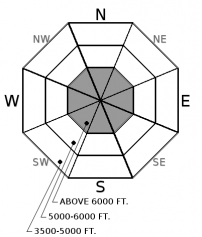
How to read the forecast
Fall Advisory Statement: Shallow, early season snow coverage exists above 6,000 ft. Avalanche concerns are minimal under our current conditions, but you are most likely to find lurking instabilities on terrain features holding deep enough snow to cover rocks and vegetation - generally wind-loaded features. If you are traveling in the alpine, carry avalanche gear and be mindful of terrain consequences. The FAC will monitor conditions through the fall and post updates as the snowpack evolves.

No Rating
?
Above 6500 ft.
No Rating
?
5000-6500 ft.
No Rating
?
3500-5000 ft.
-
Type ?
-
Aspect/Elevation ?

-
Size ?HistoricVery LargeLargeSmall

Pay attention to signs of recent wind transport and remain leery of deeper drifts or pillowy looking features. Although there are generally few avalanche concerns with our current snowpack, you are most likely to encounter instabilities on slopes or terrain features that have seen heavy wind-loading such as gullies and below leeward ridgelines. These tend to be the slopes that are most inviting for early season turns. Look for cracking underfoot or fresh drifting snow as signs of instability.
The recent avalanche fatality in Southwestern Montana is a tragic reminder that avalanches can happen this time of year. The report is here. If you are hiking, climbing, or skiing on snow covered slopes at higher elevations, be prepared for avalanche threats. Carry avalanche gear (beacon, shovel, probe), cross avalanche terrain one at a time, and check for updates on avalanche conditions. The FAC will monitor conditions through the fall and post updates as the snowpack evolves. More detailed daily advisories will begin late November or as conditions warrant.
Dust off the avalanche cobwebs by attending our 7th annual Northern Rockies Snow and Avalanche Workshop on November 4th. It is going to be a great event and registration is now open!

Northwestern Montana will remain under a dry pattern through the remainder of this week and into next week. A cold front on Sunday is forecasted to bring a minor disturbance but little change to our current snowpack situation. Models are hinting at pattern change roughly 10 days out, which would create ideal indoor learning conditions for the 7th Annual Northern Rockies Snow and Avalanche Workshop.
This advisory applies only to backcountry areas outside established ski area boundaries. This advisory describes general avalanche conditions and local variations always occur. This advisory expires at midnight on the posted day unless otherwise noted. The information in this advisory is provided by the USDA Forest Service who is solely responsible for its content.
Call
Contact
In Partnership With

In Partnership With


