

Avalanche Forecast published on November 21, 2017 @ 5:52 pm
Issued by
Zach Guy - Flathead Avalanche Center
Whitefish Range
Swan Range
Flathead Range and Glacier National Park
How to read the forecast
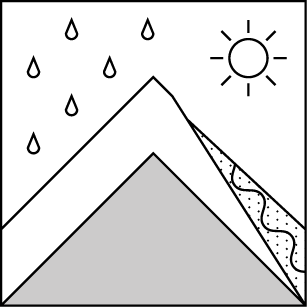
Special Avalanche Bulletin: Dangerous avalanche conditions will develop overnight and continue through Thursday. Rapid warming and significant rainfall will cause widespread areas of unstable snow at mid and upper elevations. Natural avalanches are likely. Avalanches may run into areas with minimal snow coverage. TRAVEL IN OR BELOW AVALANCHE TERRAIN IS NOT RECOMMENDED.

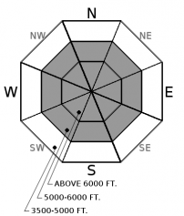
No Rating
?
Above 6500 ft.
No Rating
?
5000-6500 ft.
No Rating
?
3500-5000 ft.
Avalanche Problem 1: Loose Wet
-
Type ?
-
Aspect/Elevation ?
-
Size ?HistoricVery LargeLargeSmall

Freezing levels will rise to over 8,000 feet tonight, and more than an inch of rainfall by Thanksgiving day will be saturating and destabilizing the upper snowpack. Expect wet loose avalanches to run naturally, especially during the higher intensity rainfall at the onset of this system. Be mindful of your overhead hazards and avoid crossing below avalanche terrain .


Avalanche Problem 2: Persistent Slab
-
Type ?

-
Aspect/Elevation ?
-
Size ?HistoricVery LargeLargeSmall
Rainfall amounts are expected to exceed 1" by Thursday at all elevations. This will be adding weight to and destabilizing persistent slabs overlying a crust/facet layer near the ground on some high elevation slopes (see this observation). Slabs up to 3 or 4 feet thick have potential to fail naturally and could run into areas without much snow coverage. Minimize overhead hazards during this warmup


Forecast discussion
Due to early season coverage and limited operational resources for this time of year, we are not issuing danger ratings and daily advisories yet. However, we are staring down the barrel of our first significant avalanche cycle starting this evening. This warm and soggy system will be a shock to our dry snowpack that has been developing all of November. Keep your overhead hazards in mind if you are venturing into the backcountry this week. This includes hunters and hikers traversing through terrain that is connected to steep slopes above. Remember that closed ski areas without avalanche mitigation are equivalent to backcountry terrain right now.
Weather and CURRENT CONDITIONS
weather summary
The jet stream is tapping into sub-tropical moisture bringing a warm and wet start to Thanksgiving. Freezing levels will be soaring above 8000 feet on Wednesday and Thursday, bringing rain to all mountain locations. We will see .5" - .8" of rain this evening, with rainfall continuing on Wednesday and Thursday but tapering off in intensity. A cold front brings wind, snow, and cooler temperatures on Thursday night.
Disclaimer
This advisory applies only to backcountry areas outside established ski area boundaries. This advisory describes general avalanche conditions and local variations always occur. This advisory expires at midnight on the posted day unless otherwise noted. The information in this advisory is provided by the USDA Forest Service who is solely responsible for its content.
Search
Follow or Subscribe


In Partnership With

In Partnership With
