| Tuesday | Tuesday Night | Wednesday | |
|---|---|---|---|
| Cloud Cover: | Sunny and warm | Partly cloudy | Rain showers developing p.m. |
| Temperatures: | 46 to 51 deg. F. | 23 to 28 deg. F. | 43 to 48 deg. F. |
| Wind Direction: | S | S | S |
| Wind Speed: | 0 to 5 mph | 0 to 5 mph | 0 to 5 mph |
| Snowfall: | 0 in. | 0 in. | 0 in. |
| Snow Line: |
Whitefish Range
Swan Range
Flathead Range and Glacier National Park
How to read the forecast
The avalanche danger is LOW this morning. It will rise to MODERATE as unseasonably warm and sunny weather increases the threat of shallow wet avalanches and cornice falls. Move towards colder aspects before the snow gets too mushy and don't linger below corniced slopes.

2. Moderate
?
Above 6500 ft.
2. Moderate
?
5000-6500 ft.
2. Moderate
?
3500-5000 ft.
- 1. Low
- 2. Moderate
- 3. Considerable
- 4. High
- 5. Extreme
-
Type ?
-
Aspect/Elevation ?

-
Likelihood ?CertainVery LikelyLikelyPossible
 Unlikely
 -
Size ?HistoricVery LargeLargeSmall

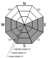
Temperatures will rise above freezing today under strong sunshine, causing the snow surface to thaw on sunbaked slopes. In terrain steeper than 40 degrees, shallow point releases will become easy to trigger or could release naturally as the snow surface becomes wet. Rollerballs or ankle-deep slush are warning signs to avoid gullies or terrain traps.
-
Type ?
-
Aspect/Elevation ?

-
Likelihood ?CertainVery LikelyLikelyPossible
 Unlikely
 -
Size ?HistoricVery LargeLargeSmall

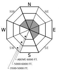
Massive cornices, the size of cars or school buses, continue to gradually weaken under our prolonged warming trend. Cornices can fail without warning and could trigger larger avalanches on the slopes below them. Choose routes that reduce your exposure to cornices and give them a wide berth while traveling along ridgelines.
Fourth verse, same as the first. Numerous small wet loose avalanches ran naturally the past three days, and we don't expect that to change today. Today's temperatures will soar even higher than the previous three. Fortunately, clear skies and cold nights are providing quality refreezes between daily warm-ups. This has limited wet instabilities to the upper-most layers of the snowpack and it provides a nice window of low avalanche danger each morning. The surface snow and sun crusts are gradually maturing with each diurnal cycle, but warmer temperatures today mean that additional slopes will probably shed. Snow that has managed to stay cooler and drier over the last few days is most suspect, such as high elevations, easterly, or westerly aspects. Shallow wet loose avalanches are easy to recognize and slow moving, but they can be harmful in terrain traps. If your plans include cliff bands or gullied terrain, get an early start and move towards shady aspects or the nearest Tiki Bar by this afternoon.
On north-facing slopes above ~4,000 feet, you can find dry powder and a generally stable snowpack. There is a spotty surface hoar layer buried about a foot deep which could cause lingering instabilities on a few shady slopes. An observer in the Northern Whitefish Range found this layer was reactive in stability tests over the weekend, and a skier in the Flathead Range was caught off guard by a small slab on Saturday and again yesterday. Deep weak layers have been dormant for more than a month, but the increasing potential for large cornice falls paired with warmer temperatures is adding more uncertainty to the equation.
Don't miss out on our final two avalanche education lectures this season at Penco Power Products in Kalispell and Whistling Andy Distillery in Bigfork. Thanks to all who participated in our avalanche education program this season and we're already planning next years line-up!
Early Spring Break 2018 culminates today, with the warmest temperatures of the year. Mountain temperatures will rise into the 40's under calm winds and plenty of sunshine. Low pressure moves onshore on Wednesday, bringing snow and rain by Wednesday night into Thursday.
This advisory applies only to backcountry areas outside established ski area boundaries. This advisory describes general avalanche conditions and local variations always occur. This advisory expires at midnight on the posted day unless otherwise noted. The information in this advisory is provided by the USDA Forest Service who is solely responsible for its content.


