| Saturday | Saturday Night | Sunday | |
|---|---|---|---|
| Cloud Cover: | Decreasing clouds | Mostly Cloudy | Mostly Cloudy |
| Temperatures: | 23 to 32 deg. F. | 14 to 19 deg. F. | 29 to 37 deg. F. |
| Wind Direction: | Southwest | East | South |
| Wind Speed: | 0 to 10 | 0 to 10 | 5 to 10, G20 |
| Snowfall: | 0" in. | 0" in. | 1" to 3" in. |
| Snow Line: | 1000' | 1500' | 3000' |
Whitefish Range
How to read the forecast
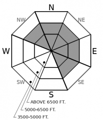
Dial it back. Dangerous avalanche conditions will develop today, complicated by buried weak layers and solar warming. There have been several accidentally triggered, large avalanches this week on shaded aspects. Sun-baked slopes will shed the new snow as the strong April sun emerges today. Conservative terrain selection is essential: the safest way to enjoy the fresh powder is on low angle terrain or on shaded aspects below 5,500'.

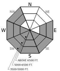
3. Considerable
?
Above 6500 ft.
3. Considerable
?
5000-6500 ft.
2. Moderate
?
3500-5000 ft.
- 1. Low
- 2. Moderate
- 3. Considerable
- 4. High
- 5. Extreme
-
Type ?
-
Aspect/Elevation ?

-
Likelihood ?CertainVery LikelyLikelyPossible
 Unlikely
 -
Size ?HistoricVery LargeLargeSmall

Two separate groups on Wednesday were surprised by large persistent slab avalanches - one was remotely triggered from a ridgeline and failed on a surprisingly low angle slope, the other released on the second skier to cross the slope. Solar warming could make this problem more reactive today. Slabs are breaking 18" to 36" deep on buried facets or faceted crusts, weak layers that are slow to heal. Erratic feedback, unusual behavior such as triggering from below or adjacent to a slope, and spatial variability are all challenges of persistent slabs that, historically, make this problem the culprit in most avalanche fatalities. It can be difficult to tease out the troublemaker slopes, so give yourself an extra wide margin for error. The easiest way to reduce your risk today is to ride on slopes less than 30 degrees in steepness or in terrain below about 5500' or so. Collapses, like the two observed by Mark yesterday, or shooting cracks are clear signs to stay on low angle terrain, although their absence is not a ticket to ride steep terrain unless you have carefully assessed the snowpack.
-
Type ?
-
Aspect/Elevation ?

-
Likelihood ?CertainVery LikelyLikelyPossible
 Unlikely
 -
Size ?HistoricVery LargeLargeSmall

Avoid crossing on or below steep, sunbaked terrain. Natural and human triggered loose snow avalanches will become increasingly larger and more sensitive through the day as the strong April sun emerges for the first time in over a week. You are likely to trigger sluffs on any aspect today. However, as the snow surface moistens on sunnier aspects, sluffs will evolve into a wetter, heavier, and more dangerous flavor of moving snow. Some may propagate as slabs. Move towards lower angle terrain or colder snow as the snow surface heats up. Pinwheels, rollerballs, or natural sluffing are warning signs of danger. With up to 2 feet of recent powder snow this week, loose snow avalanches have potential to become dangerously large, especially in long, steep gullies. Furthermore, natural sluffs can act as triggers for larger slab avalanches.
I’m going to steal a quote from an observation from Missoula's avalanche center, which hits the nail on the head. “After a month (plus) of centerpuching everything in sight with impunity, the freedom of the hills has come to an end. I’ll reiterate what [others have] said: DIAL IT BACK. The relative lack of snow in the last month has created a complex series of crusts and near-surface facet layers that are just now being tested.”
Missoula’s observations page reads a lot like ours in the past week. Collapses, unintentional triggered slides, and people nervous about buried weak layers. The downturn in loading in our neck of the woods over the last two days brought the danger down a few notches, but today it goes back up.That’s because today’s strong April sunshine, if it emerges as forecasted, will quickly warm the snow surface on all but the shadiest aspects.The danger posed by this is three-fold. First, expect natural loose snow avalanches as the dry powder moistens and sluffs down steep terrain. Loose sluffs can also act as triggers for slab avalanches. Second, the loose cohesionless snow may settle quickly enough to change slab properties in the upper snowpack, making persistent slabs more sensitive to triggers or potentially develop reactive storm slabs. And third, the warming snow will force powder seekers to north-facing aspects, which have been the biggest troublemakers for persistent slabs this week.
The danger is highest in the Flathead Range and Northern Whitefish Range, where storm totals from the past week exceed 20” at upper elevations. In these favored areas, avalanche concerns are larger and more widespread. In the Southern Whitefish and Swan Range, storm totals have been substantially smaller. Loose snow avalanches will be smaller and persistent slabs have been less active. The danger ratings on our forecast map reflect this pattern, but regardless of where you go riding today, anticipate changing conditions. It's time to dial it back and shift your mindset from the March jailbreak.
Yesterday's snow squalls brought an additional 3" to 8" of new snow, again favoring Flattop and Stahl SNOTELS. A beautiful day is in store. Brief high pressure will move across the region this afternoon. We should see a decent amount of sunshine and calm winds. The next disturbance arrives tonight into Sunday morning, bringing modest snowfall to the mountains.
This forecast applies only to backcountry areas outside established ski area boundaries. The forecast describes general avalanche conditions and local variations always occur. This forecast expires at midnight on the posted day unless otherwise noted. The information in this forecast is provided by the USDA Forest Service who is solely responsible for its content.


