| Wednesday | Wednesday Night | Thursday | |
|---|---|---|---|
| Cloud Cover: | Mostly Cloudy | Mostly Cloudy | Mostly Cloudy |
| Temperatures: | 29 to 34 deg. F. | 16 to 19 deg. F. | 21 to 27 deg. F. |
| Wind Direction: | Southwest | West | East |
| Wind Speed: | 16G29 | 11G23 | 7 |
| Snowfall: | 4" to 6" in. | 1" in. | 0" in. |
| Snow Line: | 4500' | 2500' | 1500' |
Whitefish Range
Swan Range
Flathead Range and Glacier National Park
How to read the forecast
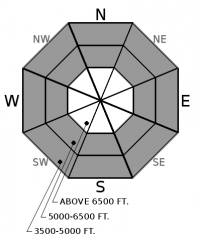
The avalanche danger is on the rise as moisture streams into our area. Thin slabs may form on weak or slick surfaces at and above treeline, increasing the threat of slab avalanches. Cracks radiating away from you or your machine is a sign of instability. Below around 5500', loose slides will be possible where rain falls on snow. Rollerballs are precursors to these slides. Seek out terrain sheltered from the wind with dry snow for a safer, more enjoyable, option.

2. Moderate
?
Above 6500 ft.
1. Low
?
5000-6500 ft.
1. Low
?
3500-5000 ft.
- 1. Low
- 2. Moderate
- 3. Considerable
- 4. High
- 5. Extreme
-
Type ?
-
Aspect/Elevation ?

-
Likelihood ?CertainVery LikelyLikelyPossible
 Unlikely
 -
Size ?HistoricVery LargeLargeSmall

Warm precipitation and windy conditions, ideal for slab development, are on tap for today. Slabs may develop on weak layers and crusts, which could inhibit bonding. They will be thickest below ridgelines and in cross-loaded gullies. Look for blowing snow and monitor new snow totals as you gain elevation. Whumpfing is bulls-eye data that weak snow is collapsing below the slab you are on. Look for softer and safer, cohesionless snow in areas sheltered from the wind and sun.
-
Type ?
-
Aspect/Elevation ?

-
Likelihood ?CertainVery LikelyLikelyPossible
 Unlikely
 -
Size ?HistoricVery LargeLargeSmall

Today’s storm is arriving with initially high freezing levels. Rain and wet snow will warm and moisten the snow surface below the snowline, which may initiate loose slides. Mushy snow is a clue that the surface bonds have weakened, and you should look for another slope to enjoy. Travel on and below low-angle slopes and avoid riding directly above terrain traps.
Moisture has returned to the Flathead for the first time since Thanksgiving. The robust high-pressure ridge, which dominated our weather for over a week, has finally broken down, allowing for a wetter pattern to enter our area. Unsettled weather is on track to impact our neighborhood this weekend with another round of snow.
Today’s storm is starting WARM! This morning, air temperatures at mountain weather stations are above freezing, with our highest station, Mt Aeneas at 7186', reporting 35 F. Fortunately, a cold front will arrive mid-morning, lowering snow levels with increasing moisture and winds. Snow totals do not look overly impressive, but a little wet snow will go a long way.
The week of high and dry conditions cultivated an impressive crop of surface hoar and near-surface facets at all elevations and most aspects (Observation, Observation). Farming is a fickle occupation, and we lost some of these crops to wind and sun damage. Tuesday’s warm and humid weather put the hurt on some of the remaining survivors. However, Clancy and I found intact surface hoar in the northern Whitefish Range yesterday (Observation). Surface hoar and near-surface facets are weak layers notorious for their role in avalanche activity and can be dangerous if they are covered over by fresh wind slabs. Not only are they more reactive to loading (snow, you, and/or your machine), but they can release wider than expected.
A stout sun crust on steep southerly aspects open to the sky is another problem layer. Incoming snow may not adhere to the crust, resulting in loose slides or slab avalanches which run further than expected. Beneath the crust lies a layer of weak facets, making this the dreaded facet-crust combo. This combination might come into play in the coming week as snow continues to accumulate, resulting in a much larger avalanche.
If you enjoy the fresh snow in the next few days, let us know what you saw. It can be as simple as sending us a photo. You know, a picture is worth a thousand words. We are quite interested in avalanche observations. Share a picture or tell us a little about it. Your observations go a long way to make our product better. Thanks.
Today, FAC starts daily avalanche forecasts scheduled to run through early-April.
An easy way to stay in touch with the snowpack is with our handy Snowpack Tracker.
Check out this winter's avalanche safety course schedule and sign up for a class that fits your needs.
A warm wet system is slowly making its way into the Flathead Valley this morning. A cold front is on track to arrive mid-morning with decreasing freezing levels and increasing winds and moisture. A brief period of high pressure returns tomorrow before another round of unsettled weather this weekend.
This forecast applies only to backcountry areas outside established ski area boundaries. The forecast describes general avalanche conditions and local variations always occur. This forecast expires at midnight on the posted day unless otherwise noted. The information in this forecast is provided by the USDA Forest Service who is solely responsible for its content.


