| Sunday | Sunday Night | Monday | |
|---|---|---|---|
| Cloud Cover: | Mostly Cloudy | Mostly Cloudy | Mostly Cloudy |
| Temperatures: | 25 to 31 deg. F. | 21 to 25 deg. F. | 29 to 34 deg. F. |
| Wind Direction: | Southwest | Southwest | Southwest |
| Wind Speed: | 27G59 | 38G63 | 45G71 |
| Snowfall: | 1" in. | 4" to 5" in. | 2" to 3" in. |
| Snow Line: | 3500' | 3500' | 4000' |
Whitefish Range
Swan Range
Flathead Range and Glacier National Park
How to read the forecast
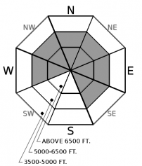
Dangerous avalanche conditions are developing with steady wind, snow, and rain. Thickening slabs may fail naturally or from a human trigger, with debris large enough to bury you. Recently-triggered avalanches should be a wake-up call to enjoy the new snow on low-angled slopes not connected to avalanche terrain. Slides on buried weak layers and crusts may result in surprisingly large avalanches. Give your friends and loved ones the gift of your safe return home.

3. Considerable
?
Above 6500 ft.
3. Considerable
?
5000-6500 ft.
2. Moderate
?
3500-5000 ft.
- 1. Low
- 2. Moderate
- 3. Considerable
- 4. High
- 5. Extreme
-
Type ?
-
Aspect/Elevation ?

-
Likelihood ?CertainVery LikelyLikelyPossible
 Unlikely
 -
Size ?HistoricVery LargeLargeSmall

Windy! Yesterday’s blustery conditions formed slabs at all elevations in leeward and cross-loaded terrain exposed to the wind. The current storm rolled in overnight, adding fuel to the fire with fresh snow and more wind for transport. Dense slabs are forming on generally weaker snow, which will give them a hollow sound and feel. They will be thickest and most dangerous downwind of ridges and in cross-loaded chutes. Dense, stiff snow is a clue to seek out cohesionless snow in sheltered locations. Hand pits are an easy way to identify a slab, a sliding surface, and a weak layer. If that structure is present, recreate responsibly on slopes less than 35 degrees.
-
Type ?
-
Aspect/Elevation ?

-
Likelihood ?CertainVery LikelyLikelyPossible
 Unlikely
 -
Size ?HistoricVery LargeLargeSmall

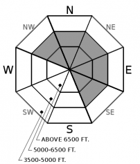
New snow and wind will add weight and stress to the weak layer of snow above the December 9 crust. We have received steady reports of triggered and natural avalanches, with the backcountry near WMR reporting incidents for each of the last four days. This layer is easy to find and identify. It is currently 1-2 feet below the surface on NW-SE slopes. In locations harboring the facet crust combination, choosing low-angle options is your best default. Allowing the snowpack to adjust to this week’s loading is well worth the wait.
-
Type ?
-
Aspect/Elevation ?

-
Likelihood ?CertainVery LikelyLikelyPossible
 Unlikely
 -
Size ?HistoricVery LargeLargeSmall

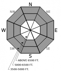
In areas not exposed to the wind, 6-10” of loose, low-density snow caps the snow surface. Today’s rain will moisten this layer and weaken what little integrity it has. Snow levels are expected to hover around 5000' leading to a rain/wet snow mix at mid-elevations. Snow falling from tree branches is one of the first clues that conditions are changing. Rollerballs, or pinwheels, are precursors to Loose Wet slides. These slides will be small, but their dense nature will make them a hassle to wrestle. If you are recreating below the snowline, choose terrain which doesn’t involve traveling above or in a terrain trap.
The well-advertised Atmospheric River flowed into our area last night and will be with us through the afternoon. These events are known for delivering warm temperatures and copious amounts of moisture. As of 6:00 a.m., snowfall amounts are a modest 4-8”, but the water totals are more impressive, with nearly an inch already recorded in favored locations such as Noisy Basin. The precipitation will taper off this afternoon before a warmer wet system arrives overnight.
The big news, avalanche wise, is the number of triggered slides in the side country of Whitefish Mountain Resort this week (Example 1, Example 2, Example 3, Example 4. One a day for the past four days is a streak not worth gloating over. Most of these avalanches failed in the weak faceted snow that is resting on the December 9 crust. We are referring to these slides as Persistent Slab avalanches. Observations from this area continue to show propagation in large column tests as the snowpack continues to struggle adjusting to the load from this past week. The weather overnight, today and tomorrow, will only make this layer more reactive to human triggering. Very little activity has been reported from elsewhere in our area, possibly because backcountry access is difficult and use is low. Persistent slabs are persistent, and this facet crust combination will be something to be aware of through the holiday season.
Today’s winds, dense snow, and warm temperatures will keep Wind Slab as our primary problem. I was in Glacier Park yesterday and was impressed with the wind transport at low-elevations in thick timber. Another observer was in the Swan and didn’t have any sign of wind affected snow. Go figure! Regardless, expect to find thick slabs of dense snow in typical windy locations. With the elevated wind speeds, slabs may form at slightly lower elevations, such as cross-loaded gullies at mid-elevations. Where slabs form on weak layers, they will remain susceptible to triggering for a few extra days.
The remnants of the atmospheric river impacting our area will diminish this afternoon. Expect a slight drying trend before another warm wet system arrives overnight.
This forecast applies only to backcountry areas outside established ski area boundaries. The forecast describes general avalanche conditions and local variations always occur. This forecast expires at midnight on the posted day unless otherwise noted. The information in this forecast is provided by the USDA Forest Service who is solely responsible for its content.


