| Monday | Monday Night | Tuesday | |
|---|---|---|---|
| Cloud Cover: | Mostly Cloudy | Mostly Cloudy | Mostly Cloudy |
| Temperatures: | 25 to 31 deg. F. | 21 to 25 deg. F. | 29 to 34 deg. F. |
| Wind Direction: | Southwest | Southwest | Southwest |
| Wind Speed: | 27G59 | 38G63 | 45G71 |
| Snowfall: | 3" to 8" in. | 3" to 10" in. | 3" to 8" in. |
| Snow Line: | 3500' | 3500' | 4000' |
Whitefish Range
Swan Range
Flathead Range and Glacier National Park
How to read the forecast
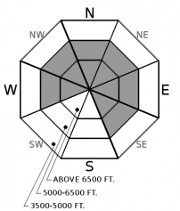
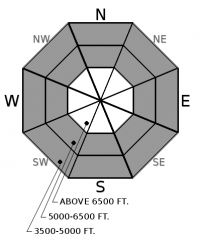
The avalanche hazard remains elevated as another warm, wet, and windy storm enters the area this morning. Heavy snowfall and rain falling on snow may trigger slabs 1 to 3 feet deep. These slabs will be thicker and more dangerous downwind of terrain features. Avalanches may step down to buried weak layers resulting in much larger slides. Natural and triggered avalanches yesterday confirm our dangerous conditions. The avalanche danger may rise to HIGH overnight into tomorrow as the storm intensifies.

3. Considerable
?
Above 6500 ft.
3. Considerable
?
5000-6500 ft.
2. Moderate
?
3500-5000 ft.
- 1. Low
- 2. Moderate
- 3. Considerable
- 4. High
- 5. Extreme
-
Type ?
-
Aspect/Elevation ?

-
Likelihood ?CertainVery LikelyLikelyPossible
 Unlikely
 -
Size ?HistoricVery LargeLargeSmall

Fresh snow and constant wind will thicken slabs that formed Saturday night into Sunday. This weekend’s natural and triggered avalanches in leeward terrain are an excellent reminder to avoid traveling downwind of ridgelines during times of elevated danger. If you climb in elevation, look for blowing snow and dune or teardrop-shaped drifts. Recreating away from wind-affected snow is both a safer and higher quality experience.
-
Type ?
-
Aspect/Elevation ?

-
Likelihood ?CertainVery LikelyLikelyPossible
 Unlikely
 -
Size ?HistoricVery LargeLargeSmall

We have received reports of triggered slides in the southern Whitefish Range for each of the past five days. These are failing on weak layers buried in our snowpack and generally associated with a crust. Today's storm will bring additional snow and wind to stress this structure, which has been found on all aspects with avalanche activity reported on N-SE aspects. This layer is generally 1-2' below the surface and relatively easy to locate. Upon locating this facet-crust combination, stick with low-angle terrain.
-
Type ?
-
Aspect/Elevation ?

-
Likelihood ?CertainVery LikelyLikelyPossible
 Unlikely
 -
Size ?HistoricVery LargeLargeSmall

Another round of rain up to around 5000’ and wet snow above will weaken surface snow and may result in loose snow slides. The near-surface snow is moist from our most recent storm, and today’s additional water may increase the threat of loose slides. If you find your machine or skis sinking into gloppy snow, it is time to call it a day or move to another slope. In conditions like these, it is best to not dawdle above or in terrain traps where wet debris can pile up like a load of wet cement.
Who’s ready for Round 2? A potent weather system will move into the area this morning and last into the day tomorrow with forecasted storm precipitation totals of 1-1.5” of water. Temperatures will rise through the day, with the snowline expected to climb up into the mid-elevations this afternoon.
The snowpack has only had around 24 hours to recover from the storm Saturday night/Sunday morning, which deposited around an inch of water in the northern Whitefish Range, interior Glacier Park, and the Swan Range. The avalanche hazard will rise as today's storm intensifies. The danger may climb to HIGH overnight into tomorrow if the forecast verifies. If so, we will issue an Avalanche Watch later today, with the expectation of moving to an Avalanche Warning overnight.
We received reports of 4 natural avalanches Sunday—one each from the Whitefish Range, interior Glacier Park, Flathead Range, and the Swan Range. A wind slab was the culprit in one of the slides, with unknown details about the type of avalanches for the other three. Mitigation work at Whitefish Mountain Resort produced sizable slides with ski cutting on slopes that had previously had explosives work. Two of these broke above patrollers, with one patroller getting knocked off his feet but escaped uninjured. These two slides were on wind loaded terrain but broke deeper in the snowpack in a weak layer buried 12/14. These slides highlight our Persistent Slab problem's variability and should be an obvious clue to be vigilant in terrain selection. A substantial load is testing our snowpack, and it is best to ride this storm out enjoying lower-angled terrain that is not connected to avalanche terrain.
Four people died in avalanches in the western U.S. on Friday and Saturday. We offer their families and friends our condolences for their losses.
Here we go again. Another strong, wet, and warm system enters our area through tomorrow.
This forecast applies only to backcountry areas outside established ski area boundaries. The forecast describes general avalanche conditions and local variations always occur. This forecast expires at midnight on the posted day unless otherwise noted. The information in this forecast is provided by the USDA Forest Service who is solely responsible for its content.


