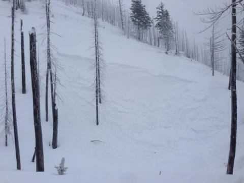
Public Observation - Triangle Peak, Flathead Range

Location Name: 
Public Observation - Triangle Peak, Flathead Range
Region: 
Swan Range - East Side (Hungry Horse Reservoir access)
Date and time of avalanche (best estimate if unknown): 
Sun, 02/05/2017 - 14:16
Location Map: 


Red Flags: 
Recent avalanche activity
Whumphing noises, shooting cracks, or collapsing
Recent loading by new snow, wind, or rain
Rapid warming
Terrain Trap

Observation made by: Public
Avalanche Observations
Avalanche Type: 
Slab
Slope: 
40degrees
Trigger type: 
Natural
Crown Height: 
3 ft
Aspect: 
West
Weak Layer: 
Within storm snow
Avalanche Width: 
100ft.
Terrain: 
Near Treeline
Elevation: 
6 200ft.
Bed Surface: 
Old Snow
Avalanche Length: 
40ft.
Number of people caught: 
0
More detailed information about the avalanche: 

Snowmobiled to Emory Creek drainage. On the way in we went through a rain layer from 3200-4000 feet. Everything above 4K was all snow. We stuck to 20-25 degree slopes up to the sub-Triangle peak ridge. Rapid warming caused the upper 2-3" of snow to become heavy and wet. We observed 24" on new snow in the protected trees. On the ridge, winds were gusting to 30 MPH from the east causing active transport onto W & NW slopes. The ridge was also firm with a 2-3 wind slab ontop of less dense snow. We observed two small windslab failures into small terrain traps. Moving back into the trees above 6,000 ft, we observed shooting cracks and tiny slab releases on tiny test slopes. Pit at 6400 feet west aspect was confusing as hell!  ICT9 on storm snow (45 cm down), ICT 22 on depth hoar (120 CM down). Total snow pack 190 cm. ECTN 11 on storm snow that only broke the width of the shovel. Otherwise, no propoagation was observed with hard force. This did not mirror other obvious signs of instability, including stomping on the snow just above the pit. The entire storm slab (about 50 CM) broke under the weight of a skier on our 20 degree slope. Stuck to the 25 degree ridge to exit back to the sleds. Exposed ridge was difficult skiing through wind crust and protected skiing was soft but difficult through heavy, deep storm snow. We got out before the cold front passed and before tonight's snow started. 

Snowpit or crown profile photo or graph: 
Avalanche observation video: 

6400' West aspect Triable Peak. 2/5/17

Weather Observations
Blowing Snow: 
Yes
Cloud Cover: 
100% of the sky covered by clouds
Air temperature: 
Below Freezing
Wind Speed: 
Moderate (Small trees sway)
Precipitation: 
Snow
Air temperature trend: 
Warming
Wind Direction: 
East
Accumulation rate: 
Less than 1 in. per hour
More detailed information about the weather: 

Warming weather caused an obvious change in the snowpack. Winds were moderate on exposed ridges above 6000 ft. 

Activity: 
Skiing