Forecaster Observation - Canyon Creek, southern Whitefish Range

Location Name: 
Forecaster Observation - Canyon Creek, southern Whitefish Range
Region: 
Whitefish Range - Southern (south of Coal Creek)
Date and time of avalanche (best estimate if unknown): 
Thu, 01/14/2016 - 11:00
Location Map: 


Red Flags: 
Recent avalanche activity
Recent loading by new snow, wind, or rain

Observation made by: Forecaster
Avalanche Observations
Avalanche Type: 
Dry
Slab
Slope: 
34degrees
Trigger type: 
Skier
Crown Height: 
1 ft
Aspect: 
East
Weak Layer: 
Old snow
Avalanche Width: 
50ft.
Terrain: 
Below Treeline
Elevation: 
6 400ft.
Bed Surface: 
Old Snow
Avalanche Length: 
100ft.
Number of people caught: 
0
Number of partial burials: 
0
Number of full burials: 
0
More detailed information about the avalanche: 

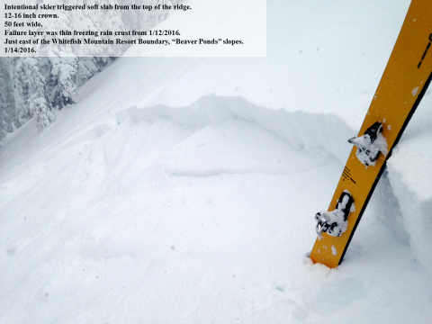
The avalanche was triggered by walking along the flat ridge above a small rollover at the top of the slope. No one was caught in the slide. The avalanche ran about 200 vertical feet into the trees below and could have buried, injured, or killed a person.

The avalanche failed on top of the freezing rain crust from 1/12/2016. The slab averaged 12 inches and the greatest depth was 16 inches. 

Snowpit or crown profile photo or graph: 
Avalanche observation video: 

January 14, 2016 - Sensitive Storm Slabs, southern Whitefish Range

Weather Observations
Blowing Snow: 
No
Cloud Cover: 
100% of the sky covered by clouds
Air temperature: 
Below Freezing
Wind Speed: 
Moderate (Small trees sway)
Precipitation: 
Snow
Air temperature trend: 
Cooling
Wind Direction: 
Southwest
Accumulation rate: 
Greater than 1 in. per hour
More detailed information about the weather: 

Snowfall throughout the late morning/early afternoon varied between 0.5 to 1 inch per hour intermittently. Southwest winds were loading leeward slopes, but not at this location.

Activity: 
Skiing