| Sunday | Sunday Night | Monday | |
|---|---|---|---|
| Cloud Cover: | Mostly Cloudy | Mostly Cloudy | Mostly Cloudy |
| Temperatures: | 23 to 29 deg. F. | 11 to 15 deg. F. | 20 to 25 deg. F. |
| Wind Direction: | West | Southwest | Southwest |
| Wind Speed: | 8G20 | 5G15 | 5G10 |
| Snowfall: | 0" to 2" in. | 0" in. | 0" in. |
| Snow Line: | 2000' | 1500' | 1500' |
Whitefish Range
Swan Range
Flathead Range and Glacier National Park
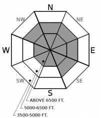
How to read the forecast
You can get into trouble with today’s fresh crop of thin slabs. These will be most dangerous where the wind has drifted them thicker and stiffer on leeward slopes. Triggering a buried layer deeper in the pack remains a concern. Minimize the potential for large dangerous slides by defaulting to lower-angled planar slopes out of the wind.

2. Moderate
?
Above 6500 ft.
2. Moderate
?
5000-6500 ft.
1. Low
?
3500-5000 ft.
- 1. Low
- 2. Moderate
- 3. Considerable
- 4. High
- 5. Extreme
-
Type ?
-
Aspect/Elevation ?

-
Likelihood ?CertainVery LikelyLikelyPossible
 Unlikely
 -
Size ?HistoricVery LargeLargeSmall

A storm is exiting our area this morning, leaving thin dense slabs in its wake. These will be consequential where the wind has drifted them 8” or thicker. You can find troublemakers like these wherever the wind loses speed: behind trees and rocks or below summits and ridgelines. They have a distinct dense or stiff feel and break into blocks while riding through them. Steer around these in favor of the plentiful soft snow found out of the wind.
-
Type ?
-
Aspect/Elevation ?

-
Likelihood ?CertainVery LikelyLikelyPossible
 Unlikely
 -
Size ?HistoricVery LargeLargeSmall

Reports of avalanches on buried layers shot through the roof this week. Weak snow surrounding the 12/9 crust buried 1-4’ deep failed, resulting in large dangerous slides. Persistent slabs are difficult to assess, and the best way to manage this problem is with terrain selection. Avoid convexities where the snowpack is stressed or pulling apart in favor of planar or concave slopes. Steer around thin spots on the slope where you or your machine can readily impact these layers. The recent storm put a hefty load on our snowpack, and we recommend choosing slope angles less than 35 degrees for a stress-free day.
Slowly our landscape is starting to look a little bit like winter. The most recent storm is exiting our area today after depositing a modest but dense 2-4” at low-elevations and 4-8” at upper elevations with 1” or more SWE recorded in the northern Whitefish Range and the Swan Range. This snow is not much in the big picture, but it is enough to keep us on our toes, especially in wind-loaded terrain where fresh slabs are thickest and most susceptible to human triggering. Storm slabs generally “heal” or strengthen within a few days of formation. The exception to the rule is when slabs form on a weak layer, such as the several inches of Champagne powder that fell Tuesday. In these situations, bonding can take longer than usual. Cracking in the slab is a telltale sign that the slab remains unstable. The opposite is true when the slab appears glued to the underlying layer in hand pits with poor quality shears. Take a little time today to investigate the bonding by sticking your hand into the snow or hitting inconsequential wind drifts with your machine or skis.
Bluebird conditions Thursday and Friday enabled observers to capture a wealth of carnage courtesy of the hurt Monday’s atmospheric river put on buried weak layers and crusts. If you enjoy this sort of thing, check out this potpourri of images and observations (Example1, Example 2, Example 3, Example 4, Example 5, Example 6, Example 7). A huge thank you to all who sent in observations and pictures of this event. Many of these slides were large enough to bury or kill you, while others had the destructive potential to destroy a wood frame house. The take away from this is that many slopes with the buried facet/crust structure from 12/9 remain intact. Although we may not see an atmospheric river for quite some time, incremental loading of the snowpack can have the same effect on these layers. We are exiting a loading event where these buried layers are most susceptible to failure from you or your machine’s weight. Our Persistent Slab problem is in its infancy, and until we feel confident removing it from our list of problems, we need to learn how to live with it. I choose slopes less than 35 degrees that are planar or concave because we have a long season of riding ahead that I don’t want to miss because of a knee injury or worse. There will be plenty of days ahead where you can safely seek out bigger, steeper terrain.
Isolated snow showers this morning before tapering off as high pressure builds this afternoon. Expect dry conditions through Tuesday with seasonable temperatures and light winds.
This forecast applies only to backcountry areas outside established ski area boundaries. The forecast describes general avalanche conditions and local variations always occur. This forecast expires at midnight on the posted day unless otherwise noted. The information in this forecast is provided by the USDA Forest Service who is solely responsible for its content.


