| Sunday | Sunday Night | Monday | |
|---|---|---|---|
| Cloud Cover: | Mostly sunny and cool | Cold and clear | Partly cloudy and warming. |
| Temperatures: | 23-35 deg. F. | 6-15 deg. F. | 31-40 deg. F. |
| Wind Direction: | S/SW | SW | SW |
| Wind Speed: | 3-4 | 3-4 | 3-5 |
| Snowfall: | 0 in. | 0 in. | 0 in. |
| Snow Line: |
Swan Range
Flathead Range and Glacier National Park
How to read the forecast
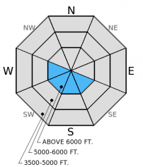
The hazard above 5000 feet is MODERATE in the Flathead and Swan Ranges today. Yesterday's gusty winds drifted recent snow and created fresh wind slabs that remain sensitive to human triggering. These slabs may range in thickness from 12-20 inches and be fairly small relative to the slope. Be especially cautious of these slabs while traveling in consequential terrrain and near terrain traps.

2. Moderate
?
Above 6500 ft.
2. Moderate
?
5000-6500 ft.
1. Low
?
3500-5000 ft.
- 1. Low
- 2. Moderate
- 3. Considerable
- 4. High
- 5. Extreme
-
Type ?
-
Aspect/Elevation ?

-
Likelihood ?CertainVery LikelyLikelyPossible
 Unlikely
 -
Size ?HistoricVery LargeLargeSmall

Human triggered wind slab avalanches remain possible today. The wind slab problem seems confined to leeward ridgelines and cross loaded terrain features like gulley walls and rock outcrops. Though distribution is somewhat isolated and size should be small relative to the slope, wind slabs formed over variable surfaces such as crusts, weak faceted snow, and graupel and will remain sensitive to human triggering today. With good visibility expected, new wind slabs can be easily identified by looking for rounded, deep, and "pillowy" features. To manage the problem, avoid steep wind loaded areas until they have had time to settle and gain strength, especially if skiing or riding in consequential terrain.
There have been recent observations of layers of weak snow in the top 1-1.5 feet of the snow pack. There have been no reports of avalanche activity associated with these layers, but it would be wise to dig a quick pit and identify any potential layers of concern before committing to a slope.
Please remember that your observations are extremely valuable. If you are out in the snow, please drop us a line and let us know what you are seeing out there. Short and sweet is all we need and there are several ways to contact us.
1) Submit on the observation page at flatheadavalanche.org
2)Call us at 406-387-3835
3) Email us at fac.admin@flatheadavalanche.org
Thank you.
The next scheduled advisory will be on Tuesday, February 24, 2015
Yesterday we traveled into the Marion Lake area in the Flathead Range. We found 4-6 inches of cold, low density snow from the previous night on top of a supportable melt-freeze crust. Along the ridgeline, winds were gusty and easily drifted the new snow onto leeward slopes (photo). The new wind slabs were very sensitive to human triggering. We experienced cracking in thin slabs on the ridgeline (photo) and found pockets of thicker slabs (16 inches) that easily propagated in extended column tests (ECTP1). The good news in this area, is that the cohesive slabs were small and confined to just below the ridge.
In the past week we observed near surface facets, graupel, and small surface hoar within the top foot of the snow pack in the Swan and Flathead Ranges (video).
Two separate parties of skiers in the southern Whitefish Range noted buried surface hoar 16-18 inches deep that propagated a fracture in extended column tests with moderate force (observation). Other recent observations reported weak layers in the upper 1-1.5 feet of the snow pack (observation).
It felt a lot more like winter yesterday with cold air from the north settling into the region along with gusty north/northeast winds. As of 4:00 a.m., mountain temperatures range from 0º F to a balmy 5º F. Winds are variable 1-3 mph. Today should see mostly sunny skies with temperatures reaching the mid-20s and winds out of the west/southwest 3-5 mph.
| 0600 temperature: | 0-5 deg. F. |
| Max. temperature in the last 24 hours: | 14-24 deg. F. |
| Average wind direction during the last 24 hours: | N/NE |
| Average wind speed during the last 24 hours: | 5-15 mph |
| Maximum wind gust in the last 24 hours: | 15-30 mph |
| New snowfall in the last 24 hours: | 0 inches |
| Total snow depth: | 65-93 inches |
This advisory applies only to backcountry areas outside established ski area boundaries. This advisory describes general avalanche conditions and local variations always occur. This advisory expires at midnight on the posted day unless otherwise noted. The information in this advisory is provided by the USDA Forest Service who is solely responsible for its content.


