Saturday | Saturday Night | Sunday | |
---|---|---|---|
Cloud Cover: | Light to moderate snow continues. | Light to moderate snow continues. | Moderate to heavy snow. |
Temperatures: | 21-34 deg. F. | 18-29 deg. F. | 26-38 deg. F. |
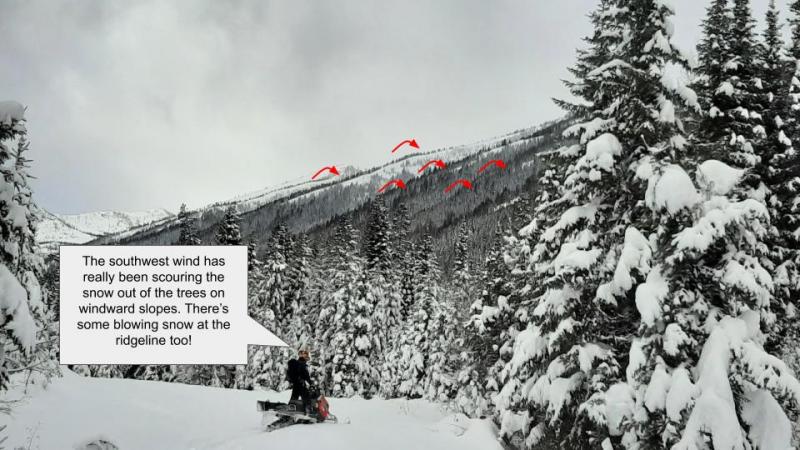
Wind Direction: | South-Southwest | South-Southwest | Southwest |
Wind Speed: | 8-9 mph with gusts to 28 | 11-14 mph with gusts to 29 | 9-12 mph with gusts to 31 |
Snowfall: | 4-7 in. | 4-8 in. | 6-10 in. |
Snow Line: |
Whitefish Range
Swan Range
Flathead Range and Glacier National Park
How to read the forecast
Dangerous avalanche conditions exist! Substantial snow has fallen at all elevations onto a weak snowpack structure. Variable wind direction has and will continue to form fresh wind slabs on all aspects. The avalanche danger is HIGH above 6000 feet. Natural avalanches are likely and human triggered avalanches are very likely. Travel in avalanche terrain is not recommended.

4. High
?
Above 6500 ft.
3. Considerable
?
5000-6500 ft.
3. Considerable
?
3500-5000 ft.
- 1. Low
- 2. Moderate
- 3. Considerable
- 4. High
- 5. Extreme
-
Type ?
-
Aspect/Elevation ?
-
Likelihood ?CertainVery LikelyLikelyPossibleUnlikely
-
Size ?HistoricVery LargeLargeSmall
Snowfall rates of 1-2" per hour occurred overnight likely forming fresh storm slabs on all aspects particularly at mid and upper elevations. This new snow was deposited onto a weak snowpack structure consisting of near surface weak layers, and crusts, along with deeper instabilities. An avalanche that initiates at the snowpack surface may step down to a deeper weak layer producing a much larger slide. Cracking in the snow surface is an obvious sign of storm slabs. It is recommended to avoid recreating in avalanche terrain today including runout zones.
-
Type ?
-
Aspect/Elevation ?
-
Likelihood ?CertainVery LikelyLikelyPossibleUnlikely
-
Size ?HistoricVery LargeLargeSmall
The storm impacting our area started off with southwesterly winds which then shifted to a more northerly flow overnight. Today, winds are forecast to shift back to a southwesterly flow. Therefore expect to find fresh wind slabs on all aspects at mid and upper elevations. Wind speeds have been sufficient to drift the new snow overnight and wind slabs will continue to form and thicken throughout today. These wind slabs are FRESH and should be easy to identify by cracking in the snow surface and newly created pillows of snow. Due to the poor snowpack structure that these slabs are being deposited on it is best to avoid wind loaded slopes today.
-
Type ?
-
Aspect/Elevation ?
-
Likelihood ?CertainVery LikelyLikelyPossibleUnlikely
-
Size ?HistoricVery LargeLargeSmall
Substantial new snow fell at all elevations overnight and will continue through the day. This snow has fallen on a variety of surfaces including low density surface snow and crusts. I anticipate that this snow will not adhere to the underlying layer and sluff easily on terrain steeper than 30°. These loose slides may be small but could knock you off your feet or machine and push you into trees or into gullies and easily ruin your day.
Friday: Guy and Mark travelled to the Skyland area of the Flathead Range. A layer of buried surface hoar was found approximately 6" below the surface in both north and south facing pits. This layer was reactive in stability tests but did not propagate due to the lack of a slab above. Soft surface snow conditions were found at mid and upper elevations.
Thursday: A resident near the Swan Range reported glide cracks that were begining to open near Peter's Ridge on a south facing slope.
Wednesday: We were in the Six-Mile area in the Swan Range. East/northeast winds continued to drift snow onto leeward slopes. Isolated wind loaded pockets along the ridgeline produced shooting cracks and even fractures 14-16 inches deep from our weight. From a distance we could see a crown line on Hall Peak from an avalanche that likely occurred early in the week. The avalanche appeared to be on a wind loaded slope and stepped down to the ground. Distance and filled in debris made it difficult to estimate size or date of the avalanche.
See below for all observations this season.
Yesterday, a strong weather system moved into our area depositing moderate to heavy snow at all elevations overnight. The valley floor in John F. Stevens Canyon near Marias Pass in southern Glacier Park has received upwards of 11" of low density snow while Noisy Basin in the Swan Range is reporting 12" of heavy dense snow. Temperatures in the Flathead and Whitefish Ranges, along with southern Glacier Park, have dropped dramatically due to northerly winds while Noisy Basin has remained in the mid to upper 20s. Currently, temperatures above 6000 feet range from -6 to 26º F. In most locations winds have shifted to the north-northeast at 4-16 mph with gusts of 9-21. Light to moderate snow will continue through today with warming temperatures and winds shifting to the southwest.
0600 temperature: | -6 to 26 deg. F. |
Max. temperature in the last 24 hours: | 15-29 deg. F. |
Average wind direction during the last 24 hours: | SW shifting to northeast |
Average wind speed during the last 24 hours: | 5-15 mph |
Maximum wind gust in the last 24 hours: | 19-32 mph |
New snowfall in the last 24 hours: | 7-12 inches |
Total snow depth: | 60-77 inches |
This advisory applies only to backcountry areas outside established ski area boundaries. This advisory describes general avalanche conditions and local variations always occur. This advisory expires at midnight on the posted day unless otherwise noted. The information in this advisory is provided by the USDA Forest Service who is solely responsible for its content.