THIS AVALANCHE FORECAST EXPIRED ON April 1, 2017 @ 11:46 pm
Avalanche Forecast published on April 1, 2017 @ 6:46 am
Issued by Mark Dundas - Flathead National Forest

Whitefish Range
Swan Range
Flathead Range and Glacier National Park

How to read the forecast

Overnight, a weak refreezing of the snow surface has resulted in another day with a loose wet avalanche problem. Recent new snow in the upper elevations has yet to consolidate and could be susceptible to triggering today. The avalanche danger is LOW. Pay attention to changing snow surface conditions and avoid consequential terrain if you or your machine start to sink below the snow surface into moist unconsolidated snow.  

1. Low

?

Above 6500 ft.
Generally safe avalanche conditions. Watch for unstable snow on isolated terrain features.

1. Low

?

5000-6500 ft.
Generally safe avalanche conditions. Watch for unstable snow on isolated terrain features.

1. Low

?

3500-5000 ft.
Generally safe avalanche conditions. Watch for unstable snow on isolated terrain features.
    Generally safe avalanche conditions. Watch for unstable snow on isolated terrain features.
  • 1. Low
  • 2. Moderate
  • 3. Considerable
  • 4. High
  • 5. Extreme
Avalanche Problem 1: Loose Wet
  • Type ?
  • Aspect/Elevation ?
  • Likelihood ?
    Certain
    Very Likely
    Likely
    Possible
    Unlikely
  • Size ?
    Historic
    Very Large
    Large
    Small

At favored locations above 6000', recent cool wet weather deposited more than a foot of snow on top of the mid March rain crust. Yesterday's mostly sunny conditions and warm temperatures resulted in the first day of warming that this new snow has seen with rollerballs and loose wet activity noted as the day progressed. Temperatures this morning are hovering around freezing at most upper elevation locations which, combined with breezy conditions, has likely formed a thin surface crust on sunny aspects. With partly cloudy conditions and cooler temperatures forecast for today, natural loose wet avalanche activity should be minimal but there is still a chance that you could trigger one of these slides, especially at upper elevations. Avoid consequential terrain as a small loose wet avalanche could knock you off your feet or machine and push you into trees, over a cliff or deposit you into a gully.

Avalanche Problem 2: Cornice
  • Type ?
  • Aspect/Elevation ?
  • Likelihood ?
    Certain
    Very Likely
    Likely
    Possible
    Unlikely
  • Size ?
    Historic
    Very Large
    Large
    Small

Massive cornices exist along many of the ridgelines across the advisory area. With longer days resulting in warmer temperatures and more hours above freezing these features are continuing their weakening trend. It's important to pay attention to what is suspended above you as you travel on slopes below ridgelines. Give these features a wide berth while traveling along ridge lines as they can pull out further back than expected, even behind the solid ground. When a large cornice falls it has the potential to trigger deep instabilities that would otherwise remain dormant resulting in a large avalanche.

Forecast discussion

In the true alpine, where winter has held on to its cold temperatures and blustery winds, wind slabs still linger. Although off the problems list, there has been enough dry looose snow available for transport above 6500 feet, recently, to continue to form fresh wind slabs. Near the Continental Divide, we've had reports and seen thin but widespread wind-slabs still forming. As spring skiing missions take you higher into the mountains be cautious where winter still remains.

The wet slab cycle we saw in mid-March due to high rain levels was impressive, but I don't think we have seen the last of them. Most of these avalanches occurred in the mid-elevation band. Though we did see some storm slab activity in the high elevations the upper snow pack absorbed most of the free-water before it could pool on deeper crusts. With the fickle and often surprising weather events that Spring in northwest Montana brings it's important to pay attention to conditions that could weaken these deep layers again. Like extended periods of warm and sunny weather and rain that soaks the snow at higher elevations.

Glide cracks have also been observed opening up in many locations.  The first reported glide avalanche this season was March 25 and occurred west of the WMR ski area in the southern Whitefish Range. There is a large amount of uncertainty associated with glide avalanches, so the best way to manage them is to avoid slopes where they are present.  

recent observations

Friday: FAC staff toured in the Blaine Mountain area of the northern Swan Range where they found up to 14" of recent snow sitting on top of the mid March rain crust. This new snow was being warmed and moistened by the warm temperatures/solar input which created rollerballs and loose wet slides. The snow surface at low and mid elevations consisted of a surface crust that broke down with afternoon warming.

Thursday: Skiers in the Red Meadow area reported multiple small wet slides on sunny aspects and a breakable crust up to 6000 feet.  At 7200 feet they found 10 inches of fresh snow.  They observed a rapidly changing snow surface with the input of direct sunshine.

Wednesday: FAC staff rode into the Skyland area and observed active wind loading, but with little snow to tranport as windward slopes were nearly scoured. They saw a recent wind slab avalanche triggered by cornice fall on the east face of Slippery Bill Mountain. 

See below for all observations this season.

Weather and CURRENT CONDITIONS
weather summary

Yesterday's mostly sunny conditions allowed temperatures to climb into the mid to upper 40's at all upper elevation weather stations. Currently, mountain temperatures are 28-38º F and winds are 5-12 mph gusting to 20 mph out of the south-southwest.  Today expect clouds to enter our area as the day progresses and a chance for light precipitation by days end. Breezy conditions should be expected with temperatures in the mid to upper 30's.

Today’s weather observations near 6000 feet in the region
0600 temperature: 28-38 deg. F.
Max. temperature in the last 24 hours: 43-48 deg. F.
Average wind direction during the last 24 hours: N switching to SW
Average wind speed during the last 24 hours: 5-15 mph
Maximum wind gust in the last 24 hours: 10-26 mph
New snowfall in the last 24 hours: 0 inches
Total snow depth: 84-121 inches
Two-Day Mountain Weather Forecast Produced in partnership with the Missoula NWS
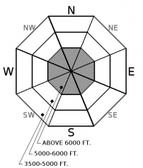
For 5000 ft. to 7000 ft.
Saturday Saturday Night Sunday
Cloud Cover: Partly cloudy with breezy conditions. Light precipitation with continued breezy conditions. Light precipitation continues.
Temperatures: 35-49 deg. F. 23-33 deg. F. 32-46 deg. F.
Wind Direction: Southwest West-southwest Southwest
Wind Speed: 10-11 gusts to 29 8-11 gusts to 28 8-11 gusts to 25
Snowfall: 0 in. 0-1 in. 0-3 in.
Snow Line:
Disclaimer

This advisory applies only to backcountry areas outside established ski area boundaries. This advisory describes general avalanche conditions and local variations always occur. This advisory expires at midnight on the posted day unless otherwise noted. The information in this advisory is provided by the USDA Forest Service who is solely responsible for its content.