Sunday | Sunday Night | Monday | |
---|---|---|---|
Cloud Cover: | Precipitation tapering off and cooler conditions. | Cool, breezy and dry. | Light precipitation returns. |
Temperatures: | 31-45 deg. F. | 15-25 deg. F. | 33-47 deg. F. |
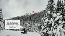
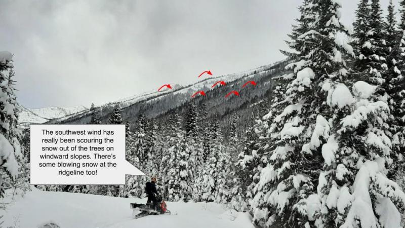
Wind Direction: | Southwest | South-southwest | South-southeast |
Wind Speed: | 10-13 gusts to 24 | 7-9 with gusts to 23 | 7-9 with gusts to 17 |
Snowfall: | 1-2 in. | 0 in. | 0-1 in. |
Snow Line: |
Whitefish Range
Swan Range
Flathead Range and Glacier National Park
How to read the forecast
Light snow overnight, combined with wind, has elevated the avalanche danger. This new and windblown snow is being deposited onto a crust which will act as a slippery bed surface for wind slabs and storm slabs. The avalanche danger is MODERATE above 5000'. Evaluate all wind loaded terrain and areas favored by snowfall before committing to a slope. Today is the last daily advisory issued by the FAC for the season.

2. Moderate
?
Above 6500 ft.
2. Moderate
?
5000-6500 ft.
1. Low
?
3500-5000 ft.
- 1. Low
- 2. Moderate
- 3. Considerable
- 4. High
- 5. Extreme
-
Type ?
-
Aspect/Elevation ?
-
Likelihood ?CertainVery LikelyLikelyPossibleUnlikely
-
Size ?HistoricVery LargeLargeSmall
Light snow overnight, combined with breezy southwesterly winds, has formed thin isolated wind slabs at favored windy locations. These slabs are sitting on top of a melt freeze crust formed due to yesterdays warming. This crust will act as a slippery bed surface and therefore these slabs may be a bit more reactive than normal. Due to the underlying bed surface these slides may run surprisingly long distances. These slabs are fresh and should be easy to identify by cracking in the surface snow beneath your skis or machine.
-
Type ?
-
Aspect/Elevation ?
-
Likelihood ?CertainVery LikelyLikelyPossibleUnlikely
-
Size ?HistoricVery LargeLargeSmall
Precipitation did not enter our area until early this morning which allowed yesterday's wet snow surface to cool and refreeze. In areas favored by snowfall and sheltered from the wind, thin storm slabs may be found at mid and upper elevation locations. These slabs will have been deposited on top of a crust which they may have a difficult time adhering to. These slabs will be small but could travel long distances and entrain a surprising amount of snow due to the underlying slippery bed surface. These slabs will be easy to identify by cracking in the snow surface beneath your machine or skis.
In areas where a slab is absent a loose dry avalanche problem may exist due to cohesion less new snow sliding on top of the near surface crust. These slides will be small but, similar to wind and storm slabs, could travel surprisingly long distances.
Thanks again to all who supported the Flathead Avalanche Center this year! We greatly appreciate all of your observations, time in the field, and sincere motivation to help save lives through avalanche education and advisories. We wish to thank the Friends of the Flathead Avalanche Center and Glacier National Park for their in-kind and financial support.
Glide cracks have been opening up in many locations. Glide avalanches are notoriously unpredictable and it is best to avoid traveling on or beneath slopes where glide cracks are present.
Saturday: Prior to this small storm, skiers in southeast Glacier Park reported very windy conditions in the Firebrand Basin area with generally poor ski conditions.
Friday: FAC staff traveled to Noisy Basin in the Swan Range where they observed recent wet loose avalanche activity from Tuesday's warm sunny weather along with older cornice debris and one glide crack. Going to the Sun Road Avalanche Program noted evidence of wet loose activity from 4/4, several glide cracks along with wet surface conditions.
A cold front moved into our area overnight which dropped temperatures and 1-6" of new snow at upper elevations. Currently, mountain temperatures range from 22-29º F with winds out of the southwest at 8-19 mph. Precipitation should taper off by mid day with mostly cloudy conditions, breezy conditions out of the southwest and temperatures in the upper 20s to mid 30s.
0600 temperature: | 22-29 deg. F. |
Max. temperature in the last 24 hours: | 34-45 deg. F. |
Average wind direction during the last 24 hours: | Southwest |
Average wind speed during the last 24 hours: | 2-21 mph |
Maximum wind gust in the last 24 hours: | 17-31 mph |
New snowfall in the last 24 hours: | 1-6 inches |
Total snow depth: | 83-121 inches |
This advisory applies only to backcountry areas outside established ski area boundaries. This advisory describes general avalanche conditions and local variations always occur. This advisory expires at midnight on the posted day unless otherwise noted. The information in this advisory is provided by the USDA Forest Service who is solely responsible for its content.