

Avalanche Forecast published on November 15, 2017 @ 1:16 pm
Issued by
Chris Bilbrey - Flathead Avalanche Center
Whitefish Range
Swan Range
Flathead Range and Glacier National Park
How to read the forecast
Early Season Snowpack Update: Another round of snowfall and wind will be impacting our region over the next 4 to 5 days. Going into the weekend, backcountry travelers should pay attention to storm totals and be wary of freshly windloaded slopes. An early season avalanche could result in an unpleasant ride over numerous obstacles due to shallow snow coverage.
The FAC will continue monitoring conditions through the fall and post updates as the snowpack evolves.

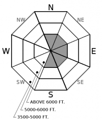
No Rating
?
Above 6500 ft.
No Rating
?
5000-6500 ft.
No Rating
?
3500-5000 ft.
Avalanche Problem 1: Wind Slab
-
Type ?
-
Aspect/Elevation ?
-
Size ?HistoricVery LargeLargeSmall

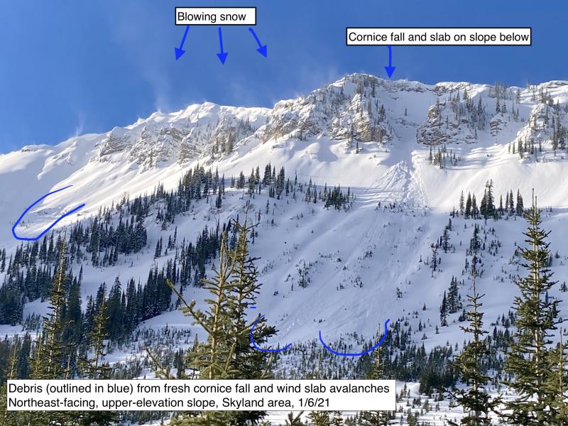
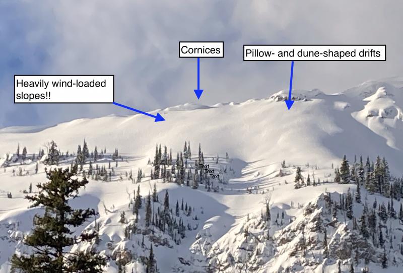
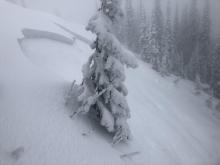
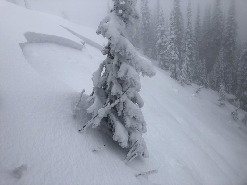
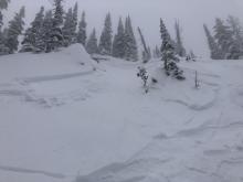
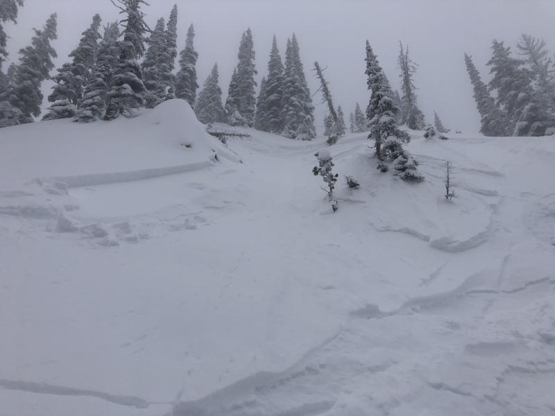
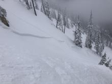
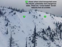
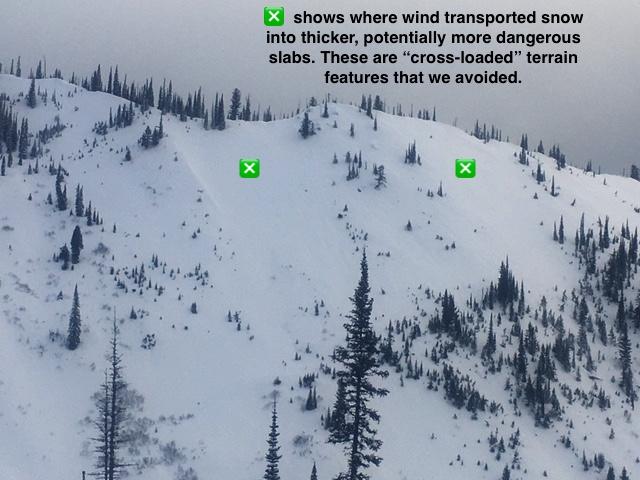
Wind slabs will continue to grow in size with the arrival of our next storm. These are most likely to be found on leeward and crossloaded slopes at higher elevation terrain from southwest progressing to northwest wind directions. Triggering a wind slab of any size in steep terrain can easily knock a skier off their feet and carry a person for a long or rough ride. Assess wind loading patterns and avoid drifted pillows of snow in higher elevation terrain.


Avalanche Problem 2: Storm Slab
-
Type ?
-
Aspect/Elevation ?
-
Size ?HistoricVery LargeLargeSmall
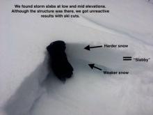
We expect to see an increasing likelihood for storm slabs to develop over the next few days with the arrival of our next storm, especially if snowfall amounts trend toward the higher end of the forecast. Use quick pits to evaluate new snow depths and bonding of the new snow/ old snow interface. If you encounter thicker or more cohesive storm snow, consider the consequences of taking a ride in steeper terrain. Cracking underfoot is a red flag for poor bonding within in the new snow.


Forecast discussion
Backcountry travels should expect changing snowpack conditions with the arrival of our next storm. Winds are forecasted to remain strong for the duration of the storm, especially in higher elevation terrain, so expect wind slabs to increase in depth over time. Southwest flow at the start of the storm will transition to a northwest flow during the storm and expand the distribution of wind-loaded slopes above treeline. Avoid deep pockets of wind-loaded snow and use quick pits on small test slopes to assess the sensitivity of newly formed wind slabs. If snowfall amounts approach a foot, be cautious crossing low angle slopes connected to steeper, wind loaded slopes above because we may see natural avalanches in steeper terrain. If we experience significant accumulations over a short time span, monitor the bonding of new storm slabs to the old snow surface as you travel up in elevation or on different aspects. You can look for cracking or jump onto small test slopes to assess this problem. With warm temps and sunny skies preempting the storm on Wednesday, expect sunny aspects to have developed a crust that could inhibit good bonding with the new storm snow.
Even though our stability tests have not been producing propagating results on the basal crust/ facet combo near the ground (such as this observation), the uncertainty and potentially large size associated with this layer warrants your attention if you are traveling on high elevation, northerly aspects. Probe or dig to see if it exists on a slope, and when in doubt, stick to sunny aspects, lower elevation terrain, and lower angled slopes. Evaluate the consequences of taking a ride before committing to steeper terrain because a surprise human triggered event could give way to a long-distance ride and potential injuries from the numerous natural obstacles located below the snow surface. When heading into the backcountry, always be prepared for the unexpected by carrying beacon, probe, shovel, first aid kit, and extra layers.
Weather and CURRENT CONDITIONS
weather summary
Our last storm brought about 2-3" of dense snow with SWE amounts ranging from 0.2-0.5" throughout Northwest Montana with the Stahl Peak SNOTEL site recording 0.8" SWE. Strong winds occured above above treeline with the cold front passage on Monday evening. Tuesday was a mixture of clouds and snow showers with temperatures warming to the mid 30's up to 6000 ft. Wednesday morning temperatures range from the mid teens to upper 20's with overall light winds and mostly clear skies.
Our next strom system and associated cold front are currently positioned along the Washington coast with a stationary front to the east of our area. For today, expect increasing clouds and southwest flow ahead of our next storm. Precipitation begins overnight Wednesday with a low pressure and associated trough forecasted to move inland and transition over Northwest Montana Thursday evening into Friday. A strong cold front arrives on Thursday with snow levels starting out around 4000 ft and lowering to 3000 ft with frontal passage. Expect strong southwest wind speeds with the frontal passage Thursday night, and by mid-day Friday, a west-northwest flow sets up over Northwest Montana. 3-7" of new snow with 0.5" of SWE is forecasted by mid-day Friday, with a few models hinting at over a foot of new snow and upwards of 1" of SWE by mid-day Saturday. Snowfall expected to persist into Sunday before winding down. Next week looks like a warming trend with the possibility of another storm system mid-week.
Disclaimer
This advisory applies only to backcountry areas outside established ski area boundaries. This advisory describes general avalanche conditions and local variations always occur. This advisory expires at midnight on the posted day unless otherwise noted. The information in this advisory is provided by the USDA Forest Service who is solely responsible for its content.
Search
Follow or Subscribe


In Partnership With

In Partnership With
