| Tuesday | Tuesday Night | Wednesday | |
|---|---|---|---|
| Cloud Cover: | Snowfall intensifying | Heavy snowfall | Temperatures dropping and flurries dissipating |
| Temperatures: | 26 to 31 deg. F. | 22 to 27 deg. F. | 18 to 23 deg. F. |
| Wind Direction: | South | Southwest | Northeast |
| Wind Speed: | 0 to 10 mph | 5 to 15 mph | 5 to 15 mph |
| Snowfall: | 7 to 9" in. | 6 to 9" in. | 1 to 3" in. |
| Snow Line: |
Whitefish Range
Swan Range
Flathead Range and Glacier National Park
How to read the forecast
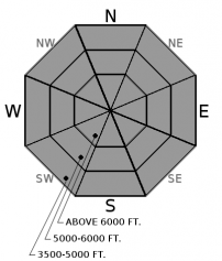
An AVALANCHE WARNING is in effect and the danger will rise to HIGH. Heavy snowfall will be overloading a weak and fragile snowpack, and a large and widespread avalanche cycle is expected later today and tonight. Very dangerous avalanche conditions exist: travel in and below avalanche terrain is not recommended.

4. High
?
Above 6500 ft.
4. High
?
5000-6500 ft.
3. Considerable
?
3500-5000 ft.
- 1. Low
- 2. Moderate
- 3. Considerable
- 4. High
- 5. Extreme
-
Type ?
-
Aspect/Elevation ?

-
Likelihood ?CertainVery LikelyLikelyPossible
 Unlikely
 -
Size ?HistoricVery LargeLargeSmall

Upwards of 20" of new snow in the past 36 hours is overloading a multitude of weak layers and crusts on all aspects and elevations. We received numerous reports of natural and human triggered avalanches and obvious signs of instability yesterday. See this video that highlights the problem. The amount of stress on these layers, and the size of slabs, are expected to double in the next 24 hours, with an additional 15" -20" of snow in the forecast. Storm slabs will be failing naturally and will be large enough to kill you. Avoid traveling on or below slopes steeper than 30 degrees, including low elevation runouts and steep forested terrain.
Today is a great day to finish your Christmas shopping or slash some powder turns at the ski resort. 12"-18" of relatively dense snow (1.5-2.4" SWE) since Sunday night is now teetering over the persistent weak layers that formed during our December drought, and significantly larger slabs have formed in windloaded terrain. The underlying weak layers are well documented in our observations page, and include surface hoar in sheltered terrain, widespread facets on all aspects, and collapsible rime or sun crusts on some slopes. Yesterday, observers in the Flathead Range reported widespread storm slab instabilities, with D1 and D2 slab avalanches running naturally at all elevations (see observation). Explosive work at Whitefish Mountain Resort yielded slab avalanches breaking up to 18" thick, and we received several reports of collapses and cracking snow in the adjacent backcountry, such as this observation. We are coming out of a slight lull overnight in snowfall and wind speeds, but snowfall will intensify through the day. If the 1.5-2.0" of forecasted SWE comes to fruition, expect the size of slab avalanches to double and natural avalanche activity to become widespread. When the dust clears tomorrow, we will see large debris piles littering our backcountry.
Join us at Stumptown Snowboards in Whitefish on January 3 at 7:00 pm for a free, engaging, and entertaining 1 hour avalanche awareness presentation. Details here.
Last night brought a brief lull in activity; snowfall rates and wind speeds tapered overnight, with most weather stations picking up less than 0.3" of precipitation. Today, a Pacific trough will carve out over the Pacific NW coast, steering a subtropical pulse of moisture across Montana. Snowfall will intensify later this afternoon and tonight. An associated cold front will briefly spike snowfall rates and wind speeds early Wednesday morning before cold, dry air takes hold under northeasterly flow for the remainder of the day. Look for 1.5" - 2.0" of Snow Water Equivalent to accumulate by Wednesday morning.
This advisory applies only to backcountry areas outside established ski area boundaries. This advisory describes general avalanche conditions and local variations always occur. This advisory expires at midnight on the posted day unless otherwise noted. The information in this advisory is provided by the USDA Forest Service who is solely responsible for its content.


