| Wednesday | Wednesday Night | Thursday | |
|---|---|---|---|
| Cloud Cover: | Flurries dissipating and temperatures dropping | Cold and dry | Snow developing late afternoon |
| Temperatures: | 14-19 deg. F. | -2 to 3 deg. F. | 15 to 20 deg. F. |
| Wind Direction: | Northeast | West | West |
| Wind Speed: | 5 to 15 mph | 0 to 10 mph | 0 to 10 mph |
| Snowfall: | 1 to 3" in. | 0 in. | 0 to 2" in. |
| Snow Line: |
Whitefish Range
Swan Range
Flathead Range and Glacier National Park
How to read the forecast
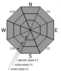
Avalanche conditions remain dangerous in the wake of a significant storm and avalanche cycle that peaked last night. In the past two days, 2 to 3 feet of snow and gusty winds have overloaded buried weak layers. Large and destructive slab avalanches will be easy to trigger on slopes steeper than 30 degrees, and natural avalanches that run through all elevation bands are possible. Patience and conservative terrain selection with an eye for overhead hazards are your silver bullets today.

3. Considerable
?
Above 6500 ft.
3. Considerable
?
5000-6500 ft.
3. Considerable
?
3500-5000 ft.
- 1. Low
- 2. Moderate
- 3. Considerable
- 4. High
- 5. Extreme
-
Type ?
-
Aspect/Elevation ?

-
Likelihood ?CertainVery LikelyLikelyPossible
 Unlikely
 -
Size ?HistoricVery LargeLargeSmall

2 to 3 feet of fresh snow accompanied by wind loading has formed dangerously thick slabs over fragile weak layers including surface hoar, facets, and faceted crusts. These slabs can be found at all elevations and aspects, but they become larger and more common at mid and upper elevations. Fresh off of a major 24-hour loading event, and with continued wind loading today, they will be reactive to human triggers and could fail naturally, producing unusually wide propagating and long running avalanches. Avoid traveling on or below avalanche terrain that has not recently flushed down to these layers, and be wary of the potential for remote triggering from adjacent low angle terrain.
Storm totals over our well documented persistent weak layers are impressive: Noisy Basin in the Swan Range has picked up 4.8" of Snow Water Equivalent (SWE), Stahl Peak in the Northern Whitefish Range is at 3.4" SWE, Flattop in Glacier National Park is at 3.6" of SWE. Settled storm totals range from 15" at Big Mountain to 3 feet in the favored areas. Winds increased overnight, blowing steadily at 20 mph and gusting into the 30's, adding additional weight to problematic structures. We observed natural avalanche activity up to D2 in size over the last two days from the Flathead Range (see observation) and in the Whitefish Range (see observation). Mitigation work at Whitefish Mountain Resort yielded widespread results. Without doubt, we experienced an impressive natural avalanche cycle in our backcountry. Although natural avalanche activity is now winding down, the threat of human triggering is VERY real. There is a long list of avalanche problems threatening backcountry travelers today: storm slabs, wind slabs, loose dry avalanches, and persistent slabs. The problem that is largest, most reactive, and most widespread is our newly developed persistent slabs, and this should dictate all of your travel decisions. Persistent slabs can be remotely triggered from low angle terrain or propagate surprisingly wide distances; give yourself an additional buffer while choosing conservative terrain. The layers lurking below this week's storm snow will not heal heal quickly and human triggering on paths that did not flush will remain a serious concern for some time.
Join us at Stumptown Snowboards in Whitefish on January 3 at 7:00 pm for a free, engaging, and entertaining 1 hour avalanche awareness presentation. Details here.
The Pacific trough that brought heavy snowfall is digging across the Western US, with cold northerly flow establishing in its wake. Mountain temperatures are in the teens and 20s this morning and will continue trending down towards zero tonight. Snow showers should wind down by mid morning, but frigid northeasterly winds will persist through the day, gusting to 30 mph at exposed locations. Northwest flow sets up through the rest of the work week; expect light snowfall and cold temperatures to continue.
This advisory applies only to backcountry areas outside established ski area boundaries. This advisory describes general avalanche conditions and local variations always occur. This advisory expires at midnight on the posted day unless otherwise noted. The information in this advisory is provided by the USDA Forest Service who is solely responsible for its content.


