| Thursday | Thursday Night | Friday | |
|---|---|---|---|
| Cloud Cover: | Increasing clouds with snow developing late afternoon. | Snow and moderate winds. | Snow ending by mid-morning with arctic air temps arriving mid-day. |
| Temperatures: | 18 to 23 deg. F. | 12 to 17 deg. F. | 5 to 10 deg. F. |
| Wind Direction: | WNW | W -> N | NE |
| Wind Speed: | 8 to 15 mph with gusts of 20 mph. | 10 to 15 mph with gusts of 25 mph. | 12 to 17 mph with gusts of 25 mph. |
| Snowfall: | 0 in. | 3 to 5 in. | 1 to 2 in. |
| Snow Line: |
Whitefish Range
Swan Range
Flathead Range and Glacier National Park
How to read the forecast
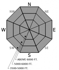
Dangerous avalanche conditions continue after a potent storm system brought 2 to 3 feet of dense snow and a widespread natural avalanche cycle through Tuesday night. Large and destructive human triggered slab avalanches are likely on slopes greater than 30 degrees. Have patience and discipline allowing buried persistent weak layers to adjust to this exceptionally large and rapid loading event.

3. Considerable
?
Above 6500 ft.
3. Considerable
?
5000-6500 ft.
3. Considerable
?
3500-5000 ft.
- 1. Low
- 2. Moderate
- 3. Considerable
- 4. High
- 5. Extreme
-
Type ?
-
Aspect/Elevation ?

-
Likelihood ?CertainVery LikelyLikelyPossible
 Unlikely
 -
Size ?HistoricVery LargeLargeSmall

Slabs from 2 to 4 feet thick recently formed over a mix of fragile weak layers such as surface hoar, facets, and crusts. These slabs can be found on all aspects and elevations, but are thicker and more widespread at mid and upper elevations. Several observations yesterday of triggered slides, collapsing, and shooting cracks are clear evidence that these dangerous slabs remain reactive to human triggers. Persistent slabs have potential to produce surprisingly wide propagation and can be triggered from below a steep, connected slope. Carefully assess the snowpack and avoid traveling on or below avalanche terrain that holds this slab over weak layer structure.
Whumpf there it is! The Mike Tyson right hander arrived Tuesday night, delivering a knock-out punch for many slopes, while leaving others teetering and ready to fall. The 3.5-5” of Snow Water Equivalent that fell on Monday and Tuesday put a staggering load on a variety of well documented persistent weak layers (photo 1, photo 2, photo 3). Numerous natural avalanches failed during this loading event that were easily large enough to bury and kill you, such as these slides in the Flathead (observation), Whitefish Range (observation), and Glacier National Park (observation). An animal triggered slide yesterday (photo) and several observations of collapses and shooting cracks are glaring signs of instability that human triggering remains likely on slopes that haven’t recently avalanched. Persistent slabs can be remotely triggered from low angled terrain and propagate surprisingly wide distances; give yourself a wide berth when traveling near avalanche terrain and runouts. Although our significant loading event and natural cycle has ended, the slopes harboring a slab over persistent weak layer structure will remain a concern well into the future.
Join us at Stumptown Snowboards in Whitefish on January 3 at 7:00 pm for a free, engaging, and entertaining 1 hour avalanche awareness presentation. Details here.
High clouds are beginning to move into northwest Montana at 5 am this morning. Snow and associated arctic air mass are forecasted to move into the region Thursday afternoon/ evening and accompanied by modearate to strong west to northwest winds. Snowfall becomes widespread across the advisory area Thursday evening and continuing into Friday morning with light to moderate accumulations. By mid-day Friday, northeast flow sets up and temps will drop throughout the day providing us with the coldest temps of the season. Another storm is forecasted for Sunday/ Monday but some uncertainty exist in the details at this time.
This advisory applies only to backcountry areas outside established ski area boundaries. This advisory describes general avalanche conditions and local variations always occur. This advisory expires at midnight on the posted day unless otherwise noted. The information in this advisory is provided by the USDA Forest Service who is solely responsible for its content.


